Monday, December 16, 2013

By the Shores of Lake Chapala


We're happy to be back at Roca Azul Resort on Lake Chapala near the town of Jocotepec. The Bus is parked in a nice spot with the lake at our backs. While in bed in the morning I can look out my window and watch the sunrise. Nice. Here's a link to Roca Azul   http://www.roca-azul.com/

One incident of note along our drive from Lo de Marcos is that the odometer on the Bus hit 100,000 miles. The really great part of this milestone is that when the odometer turned over we were traveling through fields of agave and passing by the town of Tequila. Seriously, what an appropriate place for that to happen and what a great coincidence! Couldn't have planned it better.

We really enjoy staying at Roca Azul. The resort is quite large and has a thermal pool, large swimming pool, tennis courts, a huge soccer field, and nice areas to walk. It's showing its age a bit but it's still a nice place to spend a few weeks.


The area of Roca where we're parked has several year round residents as well as seasonal residents. We've been here enough times that we've gotten to know people here and enjoy connecting with them once again. It's pretty low-key, which we like, and we find plenty to keep us occupied.
Our friends Kris and Ken had some problems with their truck this year and we were able to bring some parts down for them. Ken had things moving along well and plenty of support if he needed it. He plays the blues harp and sings, and has played at clubs in the States, some of which we've been to. He treated us to a concert one night. Wonderful to hear some live music.


Our good friend Micky lives in the town of Ajijic, which is on the northwest shore of the lake. I've known Micky since the Colorado days when we were both still working and living there. She's been in Ajijic for eleven years, teaching and working with speech/language issues in her private practice. We always have lots of laughs and fun getting caught up with things. This year was no exception - the picture below was taken at a restaurant in Chapala.


While sitting at our table along the malecon I got a picture of the mariachis tuning up and getting ready to perform.


There has been a great deal of controversy regarding the water in Lake Chapala. It's the main source of water for the city of Guadalajara. As I understand it, there are now 2 pipelines that take water from the lake and there is a movement to add another one. The people around the lake are understandably concerned. We've seen the level of water drop drastically over the last few years. In the picture below the water used to go all the way out and along the pier in the distance. Now it's gone.


Fortunately the white pelicans continue to come here. There are still large flocks of them as well as many other water birds.


Our RV friends Rick and Ruth stopped at Roca for a few nights while they were on their way to Lo de Marcos. We were delighted to give them the quick tour of the area, including the malecon in Jocotepec.


We also took them into Ajijic and Chapala. Ajijic has a lovely centro area and is a very artistic community. I took this picture at the Cultural Center. It is one of the many murals seen throughout town.


This mural is on one of the buildings around the plaza.


The murals are very colorful and representative of various events.

The following map shows the Guadalajara area and Lake Chapala. For perspective, Lake Chapala is about 50 miles long, and 10 miles wide.
The green number 1 on the map is Roca Azul, a few kilometers south of Jocotepec.
The yellow number 2 is Tlaquepaque, a suburb of Guadalajara. It's an upscale artsy area with many galleries and shops. We plan to make a day trip there. Just to the east of Tlaquepaque is Tonala, where most of the Mexican crafts are actually made. We have been there several times but haven't been back to Tlaquepaque for several years so that's where we'll go this year.
The red number 3 is Hacienda Contreras in Valle de Juarez, our next destination. We'll be there for the holidays and will probably stay several weeks.


The map below shows the towns of Jocotepec, Ajijic and Chapala.


Friday, December 6, 2013

Lo de Marcos


After our trip down the coast it was great to arrive at Lo de Marcos which is about 38 miles north of PuertoVallarta. A map of our route and location is in the previous post.

Although there are quite a few RV parks here the beach isn't crowded. We are staying at La Parota RV Park at the south end of the beach. Here's a link  https://www.facebook.com/pages/La-Parota-RV-Park/213970128694514 The park is named for the very large parota tree at the entrance.


The park itself is nice with lots of grass and concrete pads at each site, decent free wifi, free laundry and a small restaurant on the beach in front of the park. The restaurant had its grand opening for the season the night we arrived and we were treated to some good music while we had dinner. Evidently there are quite a few musicians in the area who get frequently play together. Most people are here for the winter and there's a nice sense of community among them. They have all been very welcoming and friendly. Here is a partial view of the park taken from the second floor of the community building


This is a view of the beach in front of La Parota with the restaurant on the left of the beach.


We've enjoyed walking the beach and were treated to a bit of a horse show one morning by this gentleman on his beautiful Fresian horse.


It's also been really fun to run into some of our RV friends and get caught up with them. We'll be moving on to Roca Azul near Jocotopec on Lake Chapala tomorrow but really like this area and hope to return and stay longer next time.

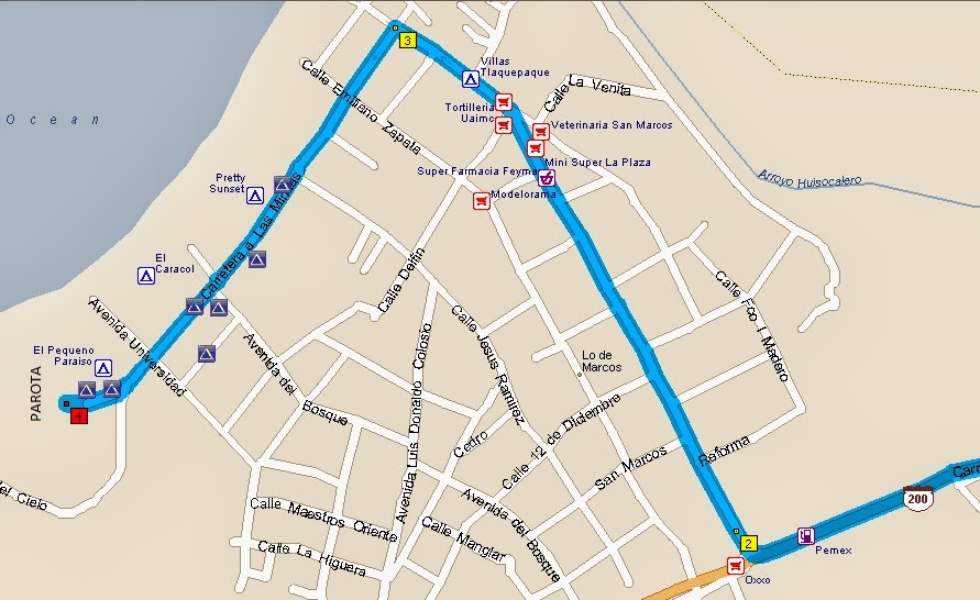
A word of caution for our fellow travelers going to Lo de Marcos. Don't follow your GPS unless you check the route first. We had directions from friends who are here and used the map in Terri and Mike Church's Traveler's Guide to Mexican Camping. Below is a map to our RV park as well as others in the area. Also a Google Earth satellite shot.


Our route tomorrow is about 200 miles.


Tuesday, December 3, 2013

Fountain Hills to Mazatlan

Our first stop after leaving Fountain Hills was De Anza Trails RV Park in Amado, Arizona. It's about 20 miles north of Nogales and a good place to overnight before crossing into Mexico.
We got an early start and were just waved through customs. We then stopped for our tourist forms and car permits. That took less than an hour and we were on our way.

Each year as we travel throughout Mexico we continue to see improvements in the road system. From Nogales south we drove through many construction zones where work is being done on the roads. In some cases they just put tar on the road and then loose gravel on top while in other areas they put down a new layer of "asfalta". But in many areas they have been completely removing the old road and building a new and wider road in its place with new roadbase and new layers of "asfalta". Yes, there is still a lot of bumpy, narrow road - but not as much as there once was.

We made the 290 miles to our first stop, San Carlos, that afternoon. It was even early enough for us to unhook the car and drive over to the Telcel office in Guaymas to get our phone and air card activated. We accomplished a lot in one day, even treating ourselves to a nice shrimp dinner.

 
Our next overnight was just south of Los Mochis where we boondocked in the back of a Pemex station, about 240 miles.
On this stretch we noted new concrete road all the way from Ciudad Obregon to Navojoa.


We had stayed at this Pemex station before and found it to be a good place to stop since it's about halfway between San Carlos and Mazatlan. There's a gated lot with a security guard - no charge, we just tip the guard. Once we pulled into the lot we saw another motorhome, the only other RV we've seen headed south. They were gone by the time we got up so they didn't get in the picture I took of our spot among the trucks.


From Los Mochis it was 256 miles to Mazatlan, our next stop.


There is a whole new section of road west of Culiacan where they have put in a diagonal road in place of the old dog leg jog. Using our "Trace GPS Route" in Microsoft Streets & Trips we are able to show the actual route we took instead of the old road still shown on the map. Our Garmin does show the new road but Streets & Trips does not show it yet. The thinner blue line on this map shows the new road.


We decided to stay at Punta Cerritos RV Park which is just north of the city and the closest RV park to get back onto our route south. The park is mostly private but has a few transient spaces. Many of the residents are building palapas, very similar to what we saw at Paamul in the Yucatan. They have brick walls, outdoor kitchens, gardens and so on. Many of them don't look like they're ever leaving.


We're spending 2 nights here, getting caught up on a few things before we move on. Our next destination is Lo de Marcos, which is north of Puerta Vallarta. It's a popular beach destination with RVers, so we thought we would check it out. Our route tomorrow is about 237 miles.


Sunday, November 17, 2013

Around the Fountain


When we're at our place in Fountain Hills we like to walk around Fountain Park every morning. Good exercise for us and Tilly loves getting out as well. We see changes around the park every time we return.
The biggest change we saw this year was the painting of the wall that surrounds the pump house. The pump house has three giant pumps that power what was once the world’s tallest fountain.  It's still the world’s tallest fountain that goes up daily – every hour on the hour for 15 minutes from 9am to 9pm.


A mural was painted on the wall years ago. When we got back to FH this fall it was covered over with white paint. Nothing happened for a few weeks. Then we saw these funny little black lines appear on the wall. We had to miss a few days of walking and when we returned the wall was painted with beautiful, colorful flowers.


We had to find out what happened. From what we can tell the project was a collaboration between the art students and the CAD (Computer Assisted Drafting) class at the high school. Once the design was created the CAD class computerized the images. They then projected the designs on the wall and drew the black lines of the mural. The students got a very large supply of spray paint cans of many colors and went to work . Some of what they did is pretty amazing and very professional looking – close up the detail shows a lot of talent. A link showing the process from start to finish can be found at Painted Petals 2013 and is pretty interesting. It shows much more detail than I have and is worth a look.


One of the things FH is known for is its donated sculptures and we see many of them around town and on our walk. Here are some of the ones we see on our walk.


This horse gets a lot of attention. It's made from a variety of weird objects - everything from egg beaters to forks to car parts.


A variety of waterfowl show up at the park throughout the year. Our favorite is the hooded merganser and we're always happy to see them return.


They all hang out together and it's fun to watch them diving and playing. From a distance they look like little sailboats.


We'll be leaving for Mexico soon - it will be interesting to see what changes have occurred by the time we return this spring.

Wednesday, September 25, 2013

Lower Antelope Canyon


This is our third visit to Antelope Canyon, located on Navajo land near Page, Arizona. There are two sections to Antelope Canyon, the Upper and the Lower. We have been through the Upper Canyon twice and the post about those visits can be found at the following link Upper Antelope Canyon.
This year we were able to go through the Lower Canyon which was quite different from the Upper. It's a longer, more strenuous hike with ladders going up and down throughout the canyon, some very narrow passageways and tricky footing in some spots.


Antelope Canyon is a slot canyon which has been formed primarily by flash floods cutting through the Navajo sandstone. Because of the risk of flash flooding, guides are required to tour the canyon. In 1997 eleven tourists were killed in a flash flood going through the Lower Canyon and there is a monument to them the entrance to the canyon. Even though the rain was falling over seven miles away on that day, it quickly moved downstream and whipped through the canyon. More safety measures have been put into place since then but there is always the risk of injuries from a flash flood.


From the surface it's very difficult to tell what lies within the canyon. I think it's a bit like scuba diving in the sense that you don't know what's beneath the surface until you go down.
It doesn't take too much imagination to find images in many of the rocks, such as the face in the photo above and the woman in the photo below.


We took our tour mid-morning which is supposed to be one of the best times because of the lighting which is a bit softer than when the sun is directly overhead.


We had a wonderful time and will do it again one day.

Tuesday, September 24, 2013

Monument Valley


This was our third trip to Monument Valley since we began RVing seven years ago. The landscape is overwhelming in size and beauty. There are miles of buttes and mesas with occasional pinnacles of rock, and the colors change with the seasons and position of the sun. Much of the scenery is familiar since it's been a backdrop for so many movies and commercials. John Ford was the first to start making movies here and John Wayne starred in several of them. There's even a cabin labeled as John Wayne's behind the old Trading Post at Gouldings. The area known as Gouldings is like a little town in the middle of the Navajo Tribal Lands which has the Trading Post, museum, restaurant, RV park, gas station and several stores. It seems that Harry and Mike Goulding bought the land from the Navajos in the 1920's but we're unclear as to how it's still private land in the middle of tribal lands.


Above is the view from the Trading Post. Brian's Aunt Mary ran the hotel at the Trading Post in the mid 1950's, and her husband Martin Gambee was an artist who painted in Monument Valley. They were there at the same time as John Ford, and the family story is that when Martin had some medical problems Mr. Ford flew Martin to Flagstaff, AZ in his private plane. Another family story tells of how Martin may have been the first white man allowed to paint the Navajo people in the 1930's. When approached by a group of Navajo men Martin got into a conversation about how the Navajos had so little facial hair. They told him they pulled out all their facial hair with pliers and asked if he could handle that. Martin said yes, and after pulling a few hairs they decided he was a good guy. Several of Martin's paintings are hanging in the museum at the Trading Post.
The RV park has a nice view of the valley and I took the picture below on the day we arrived.


 The second day was incredibly windy and there were dust storm all day. Same view on that day below.


Pretty crazy, so we put off our sightseeing until the next day which was sunny and clear. Following are some photos from our drive.


This was taken of John Ford Point which has been featured in many movies, The Lone Ranger being the most recent we know.


It's difficult to show the scope of the landscape but the little blue car on the road will hopefully give an idea its immensity.


Brian took this shot of some man-made rock sculptures in front of the real thing.


And of course Tilly and Sue enjoying the day.

There is so much information about this area which is part of what is known as the Grand Circle. Most of the people we see are from foreign countries and it seems like such a shame that we don't see more of our fellow US citizens exploring this amazing area.  Here is one of many links where more about the Grand Circle can be found . . .  http://grandcircle.org  . . .

Thursday, September 19, 2013

Colorado Flooding

We made our yearly stop in Lyons, Colorado, this year and were having a great time until the rains came. Meadow Park in Lyons has (had) 9 RV spaces and was about 30 yards from the St. Vrain River. We have always loved staying there. It's beautiful, generally very quiet, and we were able to take long daily walks along the river.

 
We had planned to leave on Thursday, Sept. 12 and fortunately had started picking things up in preparation for leaving. The rain was pretty continuous for a couple of days, and kept coming down. Wednesday afternoon Brian and I went to some of the usual places we go on our walk and were pretty amazed at the volume of water coming down the river. He took a picture of one of the bridges we usually walk over while I was standing on it. The river was much higher than we had ever seen it and we thought this picture showed how much water was flowing. At this point the water was probably still about 10 feet below the bridge.
 
 
I went to bed about 10:30 but woke up around 12:30. I could hear the river roaring and what sounded like thunder but was probably the sound of boulders crashing into each other. It was still raining hard and things just didn't seem right. I went out to the living room and Brian told me that 3 motorhomes had just left and maybe we needed to leave as well. At this point a Boulder County sheriff showed up and told us we had to evacuate. We packed everything up in the rain and dark and moved the Bus and car to higher ground at the entrance to Meadow Park. As we were evacuating I was wading through water that definitely shouldn't have been there. With memories of the Big Thompson Flood in 1976 and the devastation it caused, Brian said he thought we should keep moving and go into Longmont. Great idea. I drove the car and followed Brian and Tilly who were in the Bus. When we drove out of Lyons, water was running over the road pretty close to where we took the picture above. Very scary for me as I had visions of the car being swept away, but when I saw Brian take the Bus through I figured I could make it, and I did. We made it to the Longmont Walmart which we knew was on high ground around 3:00 AM and finally felt safe.
The next day we saw the following picture of the bridge I had been standing on. So hard to believe it.
 
 
We have been in touch with the camp hosts at Meadow Park who made it out as well, and they confirmed what we already knew - the park is gone. As far as we know our fellow campers made it out ok and some even joined us at Camp Walmart.
Once we were at Walmart we had to settle in for a few days because the roads around us were closed. We had a window of opportunity on Saturday and made it to our next stop, Colorado City which is just south of Pueblo. Evidence of flooding could be seen along our drive. The whole experience was mind boggling to say the least.  
 
The news has shown many pictures of the devastation in Lyons and the surrounding area, and it's hard to have much to add to that. We feel extremely fortunate to have gotten out when we did and made it safely to Longmont. Others have not been so fortunate. It will take months, if not years, to recover from this flood.