Saturday, July 26, 2014

The Olympic Peninsula

Hurricane Ridge, Olympic National Park


This was our second trip to Hurricane Ridge, which is part of Olympic National Park. The park encompasses mountains, forests, and beaches.
Our drive up to Hurricane Ridge began at sea level and ended at 5,242 feet. The views were spectacular, although this time it was more overcast than on our previous visit. At times it seemed as though we were in the clouds.


Once we reached the Visitor Center we got views in all directions, including across the Straits to Vancouver Island which we could barely see this time around.


There were an abundance of deer that seemed to be totally oblivious to people. This young buck was wandering through the parking lot, not panicked or anything, just wandering along.


This guy was calmly watching all the tourists go by.


Sequim

We stayed in Sequim (pronounced Skwim) while exploring Hurricane Ridge. Lovely little town that is know for its lavender. Very nice.


Rialto Beach, Olympic National Park

We stayed in Forks, Washington, home of the Twilight movies, to explore the beaches. We made a day trip out to Rialto Beach and La Push. Sea stacks, which are remnants of eroded coastal cliffs, rise out of the water just off shore.


Rialto Beach and La Push have incredible remains of immense trees. We think the trees were eroded, washed out to sea, and then washed back onto the beaches during some of the intense ocean storms. It's a great place to take photos, some of which are shown below. Hopefully they give an idea of what it's like to be there.


This kid is sitting on just one root of a massive tree base
Our routes
Mystery Bay to Sequim, 34 miles


Sequim to Hurricane Ridge, 37 miles


Sequim to Forks, 75 miles


and Forks to Rialto Beach and La Push, 27 miles


Sunday, July 20, 2014

Port Townsend


Port Townsend is a scenic little town about 17 miles from our spot on Marrowstone Island. I always enjoy wandering around there. One of its claims to fame is that the movie 'Officer and a Gentleman' was filmed in and around it. In the movie, the building above was a bar where Richard Gere got into a fight (funny the things that stick in my memory).


Port Townsend has lots of interesting shops and restaurants as well as marinas, an RV park, and a huge boat repair facility. Ferries could be seen coming and going throughout the day, while sailing school seemed to be a big hit with the kids. Their little sailboats seem so tiny, but then again so were the kids.


Wooden boats are another of Port Townsend's claim to fame. There is a huge boatyard with wooden boats both small and huge undergoing maintenance and renovation. One place that we found particularly fascinating was Pygmy Boats.


We had been by there several years ago and admired the kayaks and canoes on display. They're real works of art.


This time we were able to speak to one of the people working at Pygmy Boats. She explained that what we were seeing were demos and not available to buy since what they sell are kits to make the boats yourself. They're made of plywood panels covered with fiberglass cloth and a clear resin. Everything is included in the kit, which was voted the best kayak kit and the best wooden boat kit. We asked the price of one of the smaller kits and it was roughly $1,000. They have an informative website at   http://www.pygmyboats.com


Fort Worden is a Washington State Park that is adjacent to Port Townsend and worth a visit as well. It was originally built as a U.S. Army installation to protect the Puget Sound in the early 1900s. There are some nice beaches, an RV park, and lots of hiking trails. The picture above shows the lighthouse and outer buildings with Mt. Baker in the distance, about 65 miles away. The barracks area and officer's quarters have been preserved and are now used for conferences and rentals. Back to 'Officer and a Gentleman' again with Richard Gere's barracks and the parade grounds.


From Mystery Bay to Port Townsend, about 17 miles, an easy day trip.


Crabby in Mystery Bay


The lure of fresh Dungeness crab combined with seeing our friends has us back at Mystery Bay. We've spent two weeks eating our fill while enjoying good company in this beautiful area. We've had crab cocktails, crab soup, crab sandwiches and even a crab omelet. Judy has some great crab recipes.
Judy and Jim are park hosts at Mystery Bay for two weeks in the summer, and there's a nice RV park about a mile down the road so it's a pretty good setup. The photo above shows their boat on the left, and their friends Larry and Betty's boat on the right. Jim and Larry went crabbing every day Larry was here, then Jim carried on, keeping us well supplied with these delicious creatures. Nothing like getting it really fresh.


Once the crab pots are brought in the crab is cracked and cleaned out in the middle, as Larry is doing in the photo below.


The crabs are then boiled in a large pot over a propane stove. Brian's checking out the catch while Larry and Jim rest for a minute.


Once the crabs have been boiled they're cooled down and the pickers take over. Judy's an expert and picked at least two for each one we picked. Of course a little sampling goes on as well.


We then enjoyed the fruits of our labor, often while sitting on the deck of Jim and Judy's boat where we could see the mountains in the distance and watch the activity in the bay. There were lots of other crabbers, stand-up paddleboarders, sailors, kayakers and swimmers. Quite a busy little place.


We think that one of the most striking things about this part of the country is the way the mountains rise up above the water. We could see snow-capped mountains in the distance from the boat


and most days it was clear enough to see Mt. Rainier, about 95 miles away, from the road on the south end of the bay.


We were able to get some great views of Mt. Baker as well, about 65 miles away.


Mystery Bay is on Marrowstone Island and the nearest town of any size Port Hadlock. The maps below give an idea of where it is and how we got here. An overview of the area


and our route from Vancouver, Washington via a detour to McMinnville, Oregon (45 miles) for a bit of wine tasting


then on to Mystery Bay, 251 miles.


Tuesday, July 8, 2014

Boise to the Columbia River Gorge


From the Birds of Prey we traveled to Bend and Redmond, Oregon. Bend is a neat college town that reminded us a bit of Boulder. The Deschutes River flows through Bend and we saw lots of folks floating down the river on just about anything that floats – tubes, air mattresses, kayaks and other things we don’t know how to name. There are lots of breweries in Bend and we were able to do a bit of sampling.


In the distance we could we quite a few snow-topped peaks. Mt Bachelor, Mt Jefferson, Mt Washington and the Three Sisters were all visible.  The Sisters were originally named Faith, Hope, and Charity by early settlers, but "these names have not prevailed" and now they are named North Sister, Middle Sister, and South Sister.  They seemed to have a lot of snow for late June and we are always struck by the amount of snow we see on the mountains in the Northwest. Though these mountains may not be as high as mountains in Colorado they seem to get a great deal of snow. For example, Mount Baker (48.77707 -121.81324) recorded the largest single-season snowfall on record in the world in the winter of 1998–99 with 1,140 inches.


From Bend we headed up to Vancouver, Washington where we stayed at the Elks Lodge. We took a drive along the Columbia River Gorge east of Portland. Along the way we saw the Bonneville Dam, a National Historic Landmark (who knew) and decided to take a closer look.


Although the dams on the Columbia River are beneficial to people, there is great concern about their impact on the wild salmon population. In order to combat this, the Army Corps of Engineers is making efforts to save the salmon and other fish. At the dam and spillway adult fish swimming upstream go through a series of ladders, which are like stairways forming an artificial set of rapids. The survival rate for salmon going through the ladders is 95%. Some of the passages they swim through have lights on so that the fish won't think it's night and stop swimming. Juvenile fish are transported downstream in tanker trucks, go through the spillways or are directed by a series of screens to a juvenile bypass route. Fish that are not transported,  bypassed, or passed through spillways end up going through the turbines. Some make it through and some don't. At least it was encouraging to see the efforts being made to mitigate the effects of the dams on the river.


There are viewing areas next to the ladders that have glass panels which allow people to watch the fish. We learned about which fish migrate at what times of year and about the fish counts, all pretty interesting. This time of year it was mostly chinook and sockeye salmon, shad and the Pacific lamprey. Ugly little sucker isn't it?


There was a tour of the power plant portion of the dam and we were able to join it as last minute arrivals.


The dam is huge and the generators are huge – 20 of them. We went down into and below the generators where we could see the turbines turning the shafts that turn the generators. We were about 60 feet below the river.

It gets very technical more information  about how part of the Pacific Northwest gets their electricity can be found at
http://www.nwp.usace.army.mil/Locations/ColumbiaRiver/Bonneville.aspx

http://www.nwp.usace.army.mil/Portals/24/docs/locations/bonneville/Bonneville_FS.pdf

 Walleye, Chinook salmon, catfish, sockeye salmon, sturgeon, smoked fish, homemade fish dip and soups are ready for you to come pick up and take home!

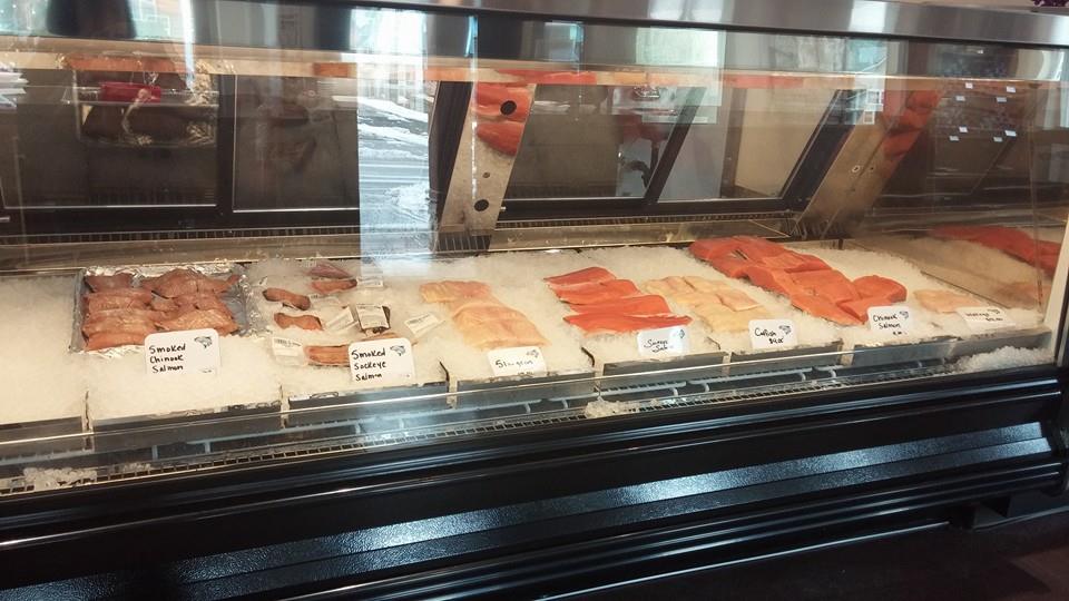
We crossed to the Oregon side of the river at the Bridge of the Gods by Cascade Locks. We were looking for some thing to eat and found the Brigham Fish Market  http://brighamfish.com where we had some fabulous food. We were able to taste several types of salmon and ordered clam and salmon chowder and other delicious river delicacies for lunch. There was a really nice write-up about the market at
http://www.oregonlive.com/travel/index.ssf/2014/05/brigham_fish_market_in_cascade.html

Brigham Market employees Katie Polzel, left, Rhian Scott and Heather Hobbs prepare the market’s signature salmon dip.

The owners of the market are members of the Confederated Tribes of the Umatilla Reservation and their families and ancestors have been fishing the Columbia for centuries. They were very interesting to talk with and they took good care of us. Highly recommend a stop there if you're in the area.

More information about the Native American Tribes and the Columbia River can be found at
http://www.critfc.org Columbia River Inter-Tribal Fish Commission
.
Our route


2) 6-23-2014 Burns, OR
3) 6-24-2014 Redmond,OR
4) 6-26-2014 Vancouver,WA
450 miles

Vancouver – Bonneville – Cascade Locks – Vancouver – 80 Miles